MāHUNT® Properties
Preserving Land for U + 1®
| Maps to and Pictures of Properties/Habitat | |||||
|
|
|||||
| Highways | Aerial Satellite |
Aerial Maps |
Aerial Pictures |
Plat | Habitat Pictures |
|
1, 2, 3, 4, 5
1, 2, 3, 4, 5 |
1, 2, 3, 4, 5 or 1, 2, 5 |
1 2 3 5 |
1 1, 2 2 3 5 |
1, 2, 3, 4, 5 |
1 2 3 4 5 |
|
|
|||||
| MāHUNT (Dunn #1) | "Dunn #1" | 38.2 Acres |
| MāHUNT (Dunn #2) | "Dunn #2" | 35.6 Acres |
| MāHUNT (Dunn #3) | "Dunn #3" | 67.5 Acres |
| MāHUNT (Dunn #4) | "Dunn #4" | 5.8 Acres |
| MāHUNT (Dunn #5) | "Dunn #5" | 46.0 Acres |
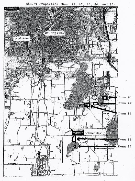
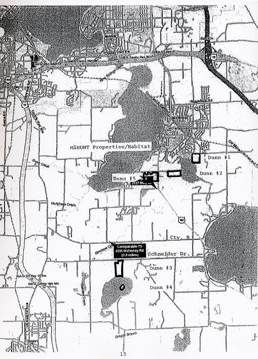
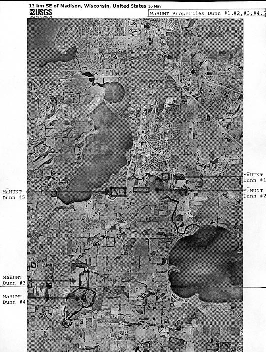
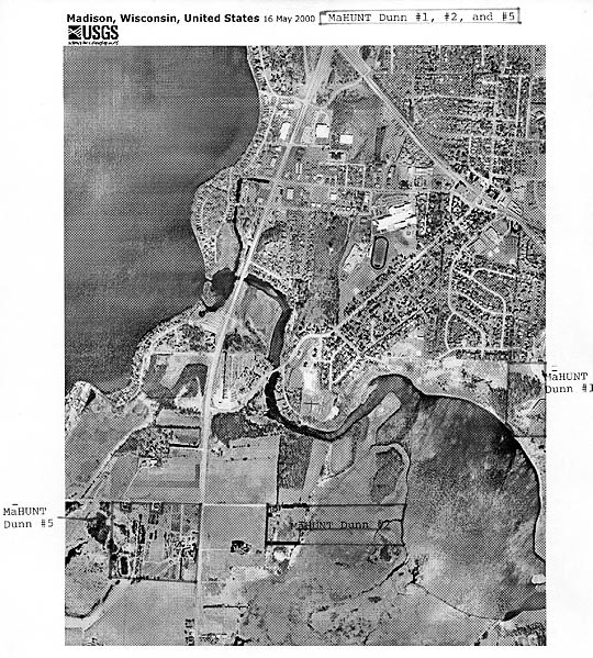
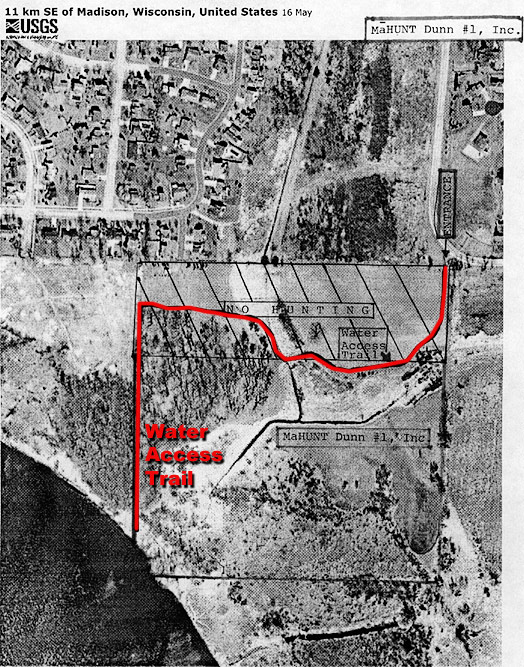
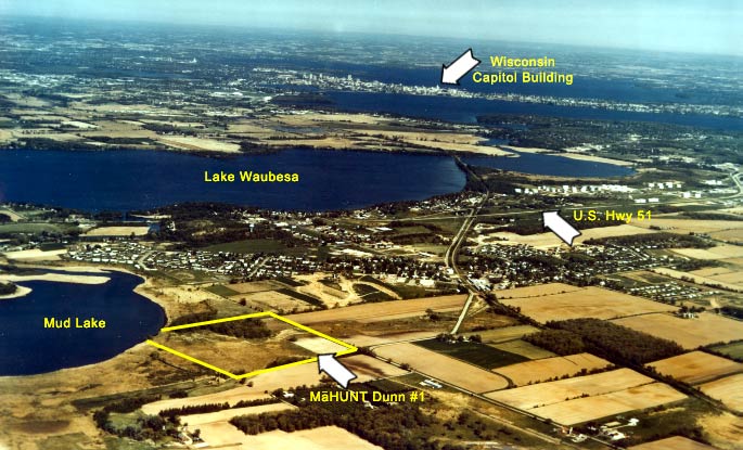
1. MāHUNT Dunn #1 (“Dunn #1”) (38.2 acres) (See Aerial Picture) is located in the Town of Dunn (southeast of Madison, WI - see aerial picture of Dunn #1 in relation to State of Wisconsin Capitol Building - and east of McFarland, WI) with its entrance on the south side at the first perpendicular bend in Elvehjem Road. Entrants should park immediately inside the gate and sign the log book or hunting log book located just right of the parking area. NO HUNTING IS PERMITTED IN THE NORTHERN 400 FEET OF THE PROPERTY – SEE AERIAL MAP FOR NO HUNTING AREA (DIAGONALLY LINED).
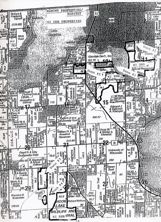
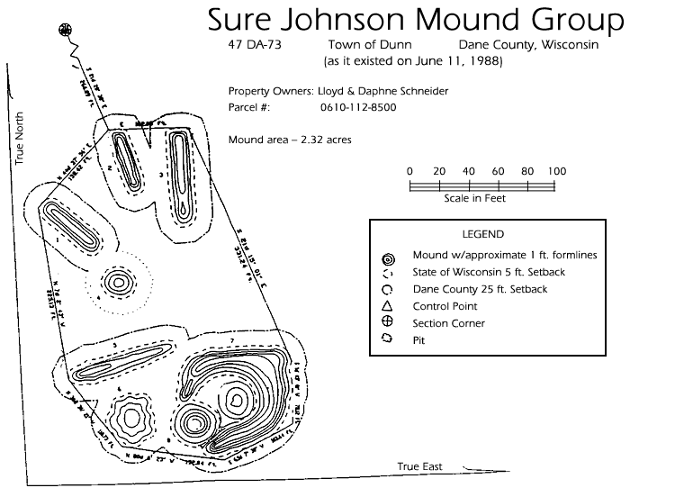
Dunn #1 encompasses eight Indian mounds in the west woods that are preserved in an open wooded area similar to their original condition when the Ho-chunk Nation lived there and sanctified the land. One mound is called an enclosure, which the U.S. Department of the Interior described as definitely the most impressive of all (of its kind) that still remain in Dane County. See Survey of Map of Mounds. The property/habitat also contains a possible site of an 1832 skirmish in the Blackhawk War where Jefferson Davis served as Battalion Commander and Abraham Lincoln reported as Captain.
One of the boundaries of Dunn #1 is Mud Lake. Mud Lake is public property below the high water mark and not owned, controlled by or associated with MāHUNT. An entrant will be allowed to take their vehicle on a predesignated limited access trail (see “Water Access Trail” on the subject property’s aerial map) through Dunn #1 in order to drive the entrant’s own floatation device or non-motorized watercraft to within fifty yards of Mud Lake. Please note that entrant’s direct or indirect use of Mud Lake of any kind whatsoever or any consequences resulting from such direct or indirect use of Mud Lake is the entrant’s and his or her companion’s (if applicable) sole and complete responsibility.
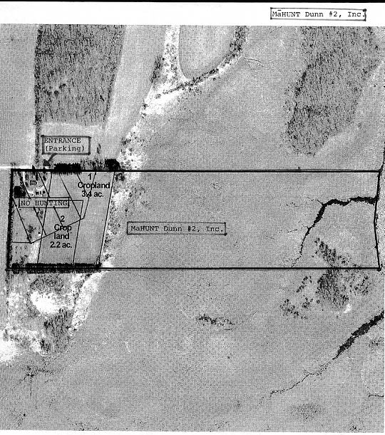
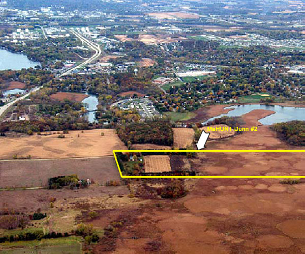
2. MāHUNT Dunn #2 (“Dunn #2”) (35.6 acres) (See Aerial Picture 1,2) (See Aerial Picture 2)is located in the Town of Dunn (south of Madison, WI and south of McFarland, WI) at 2770 E. Tower Road --- approximately one mile south of McFarland’s stop light on U.S. Highway 51 --- with its entrance at the east end of East Tower Road. Entrants should park at the east end of East Tower Road on the right hand side and sign the log book or hunting log book, which are located just inside the building just to the right forward of the parking area (not the residence to the south). NO HUNTING IS PERMITTED IN THE NORTHWEST CORNER OF THE PROPERTY WITHIN 350 FEET OF THE RESIDENCE --- SEE AERIAL MAP FOR NO HUNTING AREA (DIAGONALLY LINED).
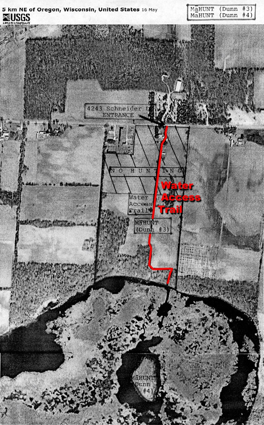
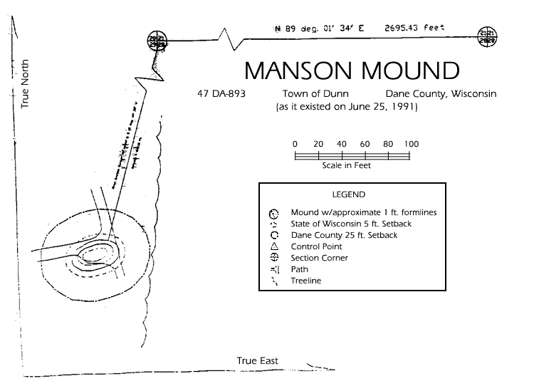
3. MāHUNT (Dunn #3). (“Dunn #3) (67.5 acres) (See Aerial Picture) is located in the Town of Dunn (south of Madison, WI and northeast of Oregon, WI) at 4243 Schneider Drive with its entrance to the south off of Schneider Drive, which runs east/west north of Stoughton and Oregon, WI. Entrants should park about three car-lengths past the first building on the property and sign the logbook or hunting log book, which are located in the small white building to the east of that parking area. NO HUNTING IS PERMITTED IN THE NORTHERN APPROXIMATELY ONE-THIRD OF THE PROPERTY (NORTH OF THE TOP OF THE FIRST HILL) – SEE AERIAL MAP FOR NO HUNTING AREA (DIAGONALLY LINED).
A partially preserved single Indian mound is located on the highest point of ground that overlooks Hook Lake. See Conservation Easement Map for its location and see Manson Mound for its exact boundaries.
Dunn #3 is subject to a conservation easement in favor of the Wisconsin Department of Natural Resources and the Town of Dunn. Such easement includes the designation of an area (the “Natural Area Tract”) that is in the southern 1/3 of the property, which encompasses those wooded lands and approximately 100 yards of open fields. The following activities are prohibited in the Natural Area Tract:
• No trees, shrubs, or plants may be cut, trimmed, or damaged (including trimming, cutting or damaging the vegetation for such reasons as creating a shooting lane or construction, installation and/or operation of a tree stand)
• No natural materials (including rocks, minerals, fossils and soil) may be removed
• No new trails may be constructed
One of the boundaries of Dunn #3 is Hook Lake. Hook Lake is public property below the high water mark and not owned, controlled by or associated with MāHUNT. MāHUNT will allow an entrant to drive the entrant’s vehicle on a predesignated limited access trail (see “Water Access Trail” on the subject property’s aerial map) through Dunn #3 in order to transport the entrant’s own non-motorized watercraft to within fifty yards of Hook Lake. Please note that Entrant’s direct or indirect use of Hook Lake and its dangerous, hazardous and unstable floating bog of any kind whatsoever or any consequences resulting from such direct or indirect use of Hook Lake or the floating bog is the entrant’s and his or her companion’s (if applicable) sole and complete responsibility.
4. MāHUNT (Dunn #4). (“Dunn #4”) (5.8 acres) (See photo of Habitat) is located in the Town of Dunn (in the east-middle of Hook Lake which abutts the south end of Dunn #3). The Wisconsin Department of Natural Resources owns an undivided share in Hook Lake Island, so, it is public land and therefore, open for public use. Dunn #4 owns an undivided 1/11th share in Hook Lake Island. No free draw or blind cash bid is open for applicants through Dunn #4. Entrants to Dunn #3 do not have permission through that process to visit Dunn #4 and MāHUNT is not responsible nor liable for any activity by any Entrants or visitors to or nearby Dunn #4. NO ACCESS TO THE PROPERTY THROUGH FREE DRAW OR BLIND CASH BID THROUGH MāHUNT IS AUTHORIZED.
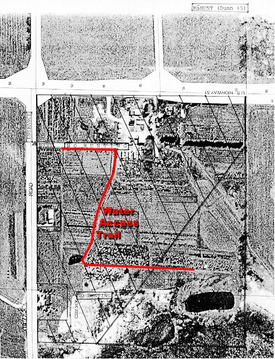
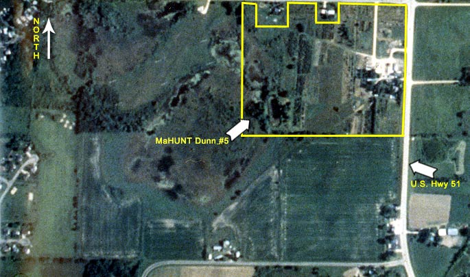
5. MāHUNT (Dunn #5). (“Dunn #5”) (46.0 acres) (See Aerial Picture) is located in the Town of Dunn (south of Madison, WI and south of McFarland, WI) at 2727 U.S. Highway 51 – approximately one mile south of McFarland’s stop light on Highway 51 – with its entrance approximately 100 feet west of U.S. Highway 51 on West Tower Road. Entrants should park about three car lengths to the south off West Tower Road just right of the gravel road and sign the log book or hunting log book, which are located just west of that parking area. NO HUNTING IS PERMITTED IN AN AREA LOCATED IN THE NORTHEASTERN (APPROXIMATELY) TWO-THIRDS OF THE PROPERTY – SEE AERIAL MAP FOR LOCATION OF NO HUNTING AREA (DIAGONALLY LINED).
Dunn #5 is subject to a conservation easement in favor of the Natural Heritage Land Trust, Inc., Dane County and the Town of Dunn. Such easement encompasses the entire property. Pursuant to the terms and conditions of the easement and rules set forth by MāHUNT, the following activities are strictly prohibited from occurring on Dunn #5:
• No trees, shrubs, or plants may be cut, trimmed, or damaged (including trimming, cutting or damaging the vegetation for such reasons as creating a shooting lane or construction, installation and/or operation of a tree stand)
• No trees, shrubs, or plants may be removed from the property by entrants.
• No swimming, fishing, jumping into or swinging over any of the three ponds that are located on the subject property is permitted.
• Be careful to stay within the boundaries of the property and not go onto any adjacent property (such as to the west of the property) where heightened hazards may exist.